The Challenge:
Mapping elevation changes in thousands of square kilometres of New Zealand landscape was previously limited to data collected by planes and drones. It was slow, small-scale and could not respond to rapid environmental changes.
The Solution:
Satellite imagery was combined with photogrammetry software to map these changes over time. A NeSI consultancy helped optimise the data processing steps, while its HPC resources allowed researchers from the Mountain Research Centre (MRC) at the University of Otago to scale-up high-resolution topographic mapping.
The Outcome:
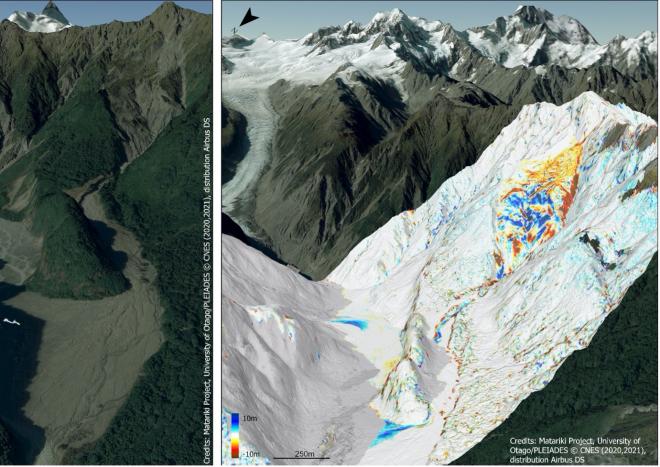
The Matariki Project was created to provide automated rapid and accurate topographic mapping services from satellite imagery to detect and monitor landscape changes. The new elevation service is designed to track changes such as those associated with landslides and glacier retreat, as well as quantify environmental resources such as snow storage and deforestation. It has already been useful to reveal unknown hazards at Murchison Hut in the Aoraki/Mt Cook National Park and to precisely quantify the recent demise of Brewster Glacier.
Dr Pascal Sirguey from the University of Otago and the Mountain Research Centre (MRC) leads a team of researchers from GNS Science and Xerra Earth Observation Institute, as well as international collaborators from France and Switzerland, using satellite imaging to monitor changes in New Zealand’s landscape.
Drs Sirguey and posts-doc Sophie Zareei are part of the Matariki Project funded by MBIE Endeavour Smart Ideas which uses satellites, in particular those from the Pléiades constellation operated by Airbus Defence and Space, to track surface elevation changes throughout New Zealand.
By turning these images into repeated 3D maps, researchers can track tree growth, snow accumulation and melt, glacial retreat, soil erosion, landslides, and or even the new shed you built in your garden.
This technology uses the 150-year old principle of photogrammetry, which develops 3D maps from overlapping 2D images. The team pulls together high-resolution images, captured by satellites at different angles to detect subtle changes in elevation on the Earth’s surface. This allows them to map hundreds of square kilometres of terrain at once, detecting changes of only a few tens of centimetres.
The challenge of this work is automating point detection in the images and achieving rapid accurate topographic reconstruction. In low contrast areas and steep terrain, like snowy mountains, a human can still easily identify the shape of the terrain, but computers struggle. The team needed to automate their program so it could recognise the same landscape over different points of time while also spotting changes. To do this, they built upon a software pipeline from the NASA Jet Propulsion Laboratory (JPL).
“We use the AMES Stereo Pipeline from JPL as the foundation for our software development. It provides us with building blocks and tools to find common points in images that vary over time, where the topography and shadows change. We used these points to create links between existing and new images that are essential to map the topography accurately and detect subtle changes,.” said Pascal.
Stakeholders of the Matariki Project could use this software to track snow storage and melt, measure changes in forest coverage, or quantify glacier downwasting to understand how climate change is impacting New Zealand. New satellite constellations are expected to make cheaper, more frequent, and better resolved imagery over the next decade, meaning the Matariki Project will provide more affordable routine updates of surface elevation, and a new way to look at and after te whenua. Government and private stakeholders could use this repeated topographical mapping to reveal and track landslides or provide rapid response following earthquakes, such as assessing elevation changes which may mean building damage.
The Project offers to provide updates of New Zealand’s topography within 48-hours following image acquisition for its partners. But for high-resolution mapping, available computing power becomes a bottleneck to reach this goal. NeSI helped them to overcome this challenge.
“To compare and process these images, we need a large amount of processing power and memory. We used the NASA JPL pipeline because it was designed to be highly parallelized. But a 400-square-kilometre map could take two days of uninterrupted processing. That’s where the NeSI consultancy helped,” said Sophie.
The team used NeSI’s Mahuika supercomputer to perform this high-resolution photogrammetry, which involved making their program scalable. NeSI Research Software Engineers Wolfgang Hayek and Maxime Rio helped the team through a NeSI consultancy, working with the researchers to optimise their code, make it run faster, use less core hours, and therefore more attractive to external users.
“We needed people with good insider knowledge of the HPC system to make our program scalable for when we transitioned from our local CPUs to NeSI. They helped us identify bottlenecks in our code and optimise our CPU calling,” said Pascal.
The Matariki Project already provides support to monitor rapid changes in the Fox Glacier / Te Moeka o Tūawe valley where GNS Science established a natural laboratory and monitoring programme. The project also achieved the first mapping of snow depth over the Main Divide of the Southern Alps / Kā Tiritiri o te Moana which provided a proof of concept for a new study founded by The Deep South / Te Kōmata o Te Tonga National Science Challenge.
The scale-up permitted by NeSI resources will allow processing of 5,000 km2 of satellite stereo imagery to map the spatial and temporal distribution of snow in the Aoraki / Mt Cook National Park to validate NIWA snow model and better understand catchment processes. The software developed as part of the Matariki Project aims to be open-access once ready. This research could be used around the world to track responsible land use and potential hazards.
By providing HPC resources and expertise to the Matariki Project, NeSI is helping New Zealand researchers build international connections and improve early detection of environmental hazards, and efficient management of natural resources.
Do you have an example of how NeSI support or platforms have supported your work? We’re always looking for projects to feature as a case study. Get in touch by emailing support@nesi.org.nz.