
A scalable digital elevation builder for flood mapping
"NeSI is really the only platform for producing our hydrologic condition digital elevation models at the national scale."
Subject:

The race is on for the development of next generation climate simulation models, which will allow us to predict future climates under different greenhouse gas emission scenarios with great fidelity.
One particular challenge is to predict the impact of climate change at the regional scale. This requires high resolution simulations. The LFRic model, whose development is led by the UK Met Office and involves partners around the world, including NIWA/NeSI in New Zealand, is an example of such an effort.
NIWA, through a Consultancy project with NeSI, has been looking into ways to improve the accuracy of vector interpolation near the poles, upon which some pre- and post-processing tools rely on, for instance, to integrate the trajectories or tracers.
The north and south poles are very weird points on a longitude-latitude grid. The north and east directions are not well defined there and so the ability to accurately compute vector fields there, as well as other quantities, remains a numerical challenge.
NeSI/NIWA research software engineer Alex Pletzer teamed up with University of Exeter researcher Tim Andrews. Together they looked at different interpolation algorithms and found that the highest accuracy was achieved by performing the interpolation in a space where there is no singularity, and where the grid cells look like squares.
As a second step, the vector field is converted to the longitude-latitude coordinate system using exact formulas.
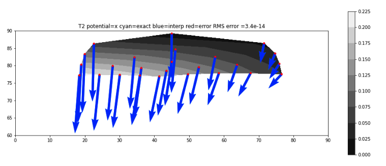
A method that takes horizontal staggered vector data and allows vector fields to be reconstructed anywhere on the globe. The picture below shows an example of a nearly perfect field reconstruction for a highly distorted cell near the pole. The differences between the numerically reconstructed field and the exact field are at the levels of machine roundoff errors.
"Recent work on MINT (Mimetic INTerpolation) has helped to refine the numerical methods. The benefits are of particular relevance to the regridding of atmospheric data on the globe, such as dealing with the shapes of cells near the pole of a lat-lon grid. Alex has provided clarity on understanding the problem and has worked with collaborators to provide and document novel solutions. These refinements make MINT an appealing option for future data regridding requirements.”
- Christine Johnson, Met Office, UK
Do you want to bring your research to the next level? We can help. Send an email to support@nesi.org.nz to learn more about our Consultancy support.


