
Predicting druglikeness in new compounds
A Case Study prepared by Daniel Moscoh Ayine-Tora and Jóhannes Reynisson of the School of Chemical Sciences, University of Auckland
Subject:
Seismologist Yoshi Kaneko of GNS Science has used an advanced 3D wave propagation code on NeSI’s Power 6 supercomputer to simulate complex seismic wave propagation generated by earthquakes in the North Island of New Zealand.
With help from Dr Francois Bissey of NeSI’s Computational Science team, Yoshi and his research colleagues are trying to understand the influence of large-scale geological features, such as sedimentary basins, volcanic zones and stiffer subducted slab on the resulting surface ground motions.
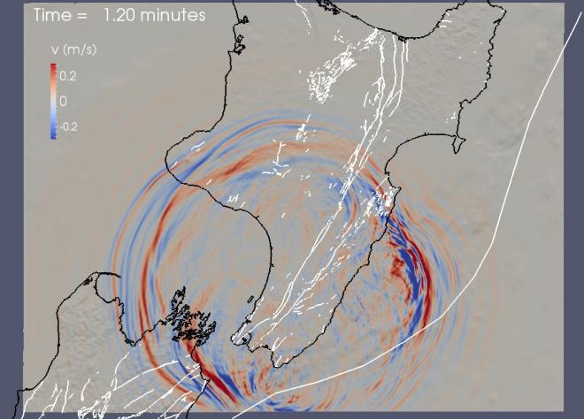
Seismic waves generated by earthquake faulting in New Zealand travel through sedimentary basins, mountains, crust and deep subducted slab. By comparing simulated and observed waveforms recorded at seismometer stations, researchers can quantify their understanding of the crustal structure of New Zealand that was previously inferred from seismological and geophysical studies.
To do this, Yoshi and his colleagues simulate seismic waves from well-studied, local earthquakes using a highly-accurate numerical technique called a spectral element method. They have constructed a computational mesh that includes surface topography, bathymetry and the latest 3D geological/seismological model of the North Island and the northern South Island. They then validate their approach by simulating seismic waves using many earthquakes and comparing them to waveforms observed at New Zealand’s dense seismic network (See the video below). Without NeSI’s supercomputer, they cannot run the software with a sufficient resolution.
In addition, using a similar approach, the researchers have been developing a set of potential rupture scenarios for great earthquakes in the lower North Island. Great earthquakes, such as the 2011 Tohoku-oki earthquake in Japan, occur at subduction zones where one tectonic plate slides under the other. In the lower North Island of New Zealand, the absence of recorded past large subduction earthquakes and a unique tectonic situation preclude the use of purely empirical approaches to estimate the resulting ground motion levels. Since the Hikurangi subduction is potentially the largest contributor to seismic hazard in the lower North Island including the Wellington region, understanding physical factors controlling the levels of ground motions from destructive subduction earthquakes is critical for seismic hazard assessments. Recent advances in source characterisation, source modelling techniques and computing power provide the opportunity for a major advance in modelling realistic ground motions. The researchers have been investigating earthquake source parameters controlling the levels of strong ground motions as well as characterising the influence of large-scale geological features, such as the subducted slab, sedimentary basins, and topography on the resulting ground motions (see Figure 1 above).


