Investigating climate sensitivity
“The numerical simulations and predictions of the Earth’s climate, which are an essential component of my research, are not possible without NeSI’s high computing facility.”
Subject:

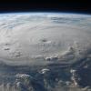
Weather forecast permeates many aspects of daily life, whether it is for planning a weekend with the family, determining whether or not to irrigate crops, identifying the most optimal flight path of an aircraft or evaluating the risk of flash floods.
Behind every numerical weather prediction (NWP) lies a sophisticated computer model, which simulates temperature, pressure, wind, cloud formation and precipitation. Combined with satellite observations, the prediction capability of weather forecast models has improved significantly over the past decades.
The National Institute for Water and Atmospheric research (NIWA) runs the Unified Model developed at the UK Met Office daily to predict the weather up to 10 days ahead for New Zealanders.
To improve forecasting capability of high impact weather, resolution must be increased from ~16 km worldwide today to about one kilometre. This is the resolution required to start representing deep air convection, which is responsible for the formation of storm clouds. Unfortunately, an increase of 16x in horizontal resolution translates into a 300+ times higher demand for computational resources [2], making km-scale models computationally very expensive to run.
To address this challenge, the UK Met Office and partners (NIWA, Bureau of Meteorology Australia, Korea Met Admin, NCMRWF India) are developing a high fidelity weather and climate code named LFRic, after Lewis Fry Richardson, a meteorologist who dreamt about applying parallel computing for weather prediction in the 1920s.
LFRic will rely on a cubed-sphere to alleviate the problems of numerical instabilities affecting longitude-latitude grids at the poles, apply a “separation of concerns” approach where the mathematical models are decoupled from their implementation to achieve high, exascale parallel performance on a variety of hardware, and leverage a new discretisation scheme based on mixed finite elements where fields are attached to grid nodes, edges, faces and cells.
This new discretisation scheme offers the promises of achieving higher numerical fidelity with fewer degrees of freedom.
Few tools, however, are currently designed to handle vector fields attached to edge and face cells. Simple and widely used post-processing operations, for instance visualisation and interpolation, require fields to be either defined on nodes or cells.
NeSI high performance computing research software engineers Alexander Pletzer and Wolfgang Hayek have developed a new interpolation method [1] that is suited for vector fields on grid cell edges and faces.
Unlike other methods, the new interpolation method conserves line and flux integrals, a property that makes the method “mimetic”. This work was recently published in the American Meteorological Society's Monthly Weather Review Journal. To read the paper, Mimetic Interpolation of Vector Fields on Arakawa C/D Grids, click here.
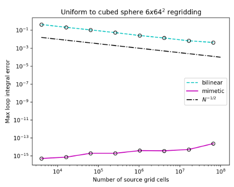
The picture below shows the improvement in accuracy from the dashed, cyan line obtained by applying the most common interpolation method (bilinear), compared to the solid, magenta line obtained using the new, mimetic interpolation method. The error for the mimetic method is more than five orders of magnitude lower.
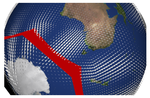
The mimetic interpolation method has been implemented in a library (MINT), which is openly accessible (https://github.com/pletzer/mint). The library supports arbitrary 2D meshes made of quadrilateral cells and allows users to compute flux integrals. An example is the flux across the red area in the picture below.
Many earth science phenomena rely on conservation of water, energy, vorticity and other quantities so it is important to ensure that both dynamic models and post-processing tools honour conservation regardless of the grid resolution.
References
[2] Numerical techniques of cloud-resolving model and large eddy simulation: https://wmo.int


