
War on wildings
"Building a scientific model/theory to solve complex real world problems is one thing but scaling it up to solve the problems in a timely manner and utilizing all the modern computational resources is another."
Subject:
The Challenge:
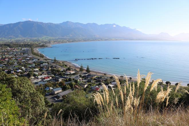
Coastal sea levels around New Zealand may rise up to a metre by the end of this century. With two-thirds of New Zealanders living less than 5 km from the coast, the dangers of erosion and flooding affect almost every single person.The Solution:
Long-term, high-resolution models are vital to make informed decisions to protect houses, industries and environment from coastal erosion and flooding.The Outcome:
Greg Pearson, a Meteorological Design Engineer with MetService, is using NeSI's HPC platform to power a high-resolution model as part of the Moana project, an $11.5 million Endeavour Fund project to understand coastal ocean circulation, the ocean environment and the impact of heatwaves.
Coastal sea levels around New Zealand may rise up to a metre by the end of this century. With two-thirds of New Zealanders living less than 5 km from the coast, the dangers of erosion and flooding affect almost every single person. Long-term, high-resolution models are vital to make informed decisions to protect houses, industries and environment.
Greg Pearson, a Meteorological Design Engineer with MetService, is using NeSI's HPC platform to power one such model of New Zealand’s coastal waters. Greg’s research is part of the Moana project, an $11.5 million project funded by the Ministry for Business, Innovation and Employment Endeavour Fund to understand coastal ocean circulation, the ocean environment and the impact of heatwaves.
“There’s a trade-off. You can either have a high-resolution model that only goes back one or two years, or a coarse-resolution model that goes back decades," says Greg. "We’re trying to do both here because the coastline around New Zealand is very complex.”
Greg is running a high-resolution atmospheric model that produces an historical wind climatology for New Zealand over the decades. This will be used to drive hydrodynamic ocean models for New Zealand’s coastal waters.
“This gives us a better understanding of New Zealand’s currents and its impacts on marine industries, like fisheries. These data sets will be available to other projects and research institutions.”
Greg uses ERA5 reanalysis data set from European Centre, which currently reaches back to the 1950s. He uses the Weather Research and Forecasting model to physically downscale the ERA5 data set to produce high-resolutions winds about New Zealand. These wind fields are used to drive marine models giving an understanding of New Zealand’s currents and how they change over time. But to process this data, Greg needed NeSI’s HPC resources.
“It was an intensive exercise, with a lot of data produced and data processing carried out. It is great that New Zealand is capable of producing these data sets. that can be mined by scientists with a specific goal in mind.”
Greg used the Māui supercomputer for processing the data. Because of the large number of core hours, Greg worked with NeSI's Research Software Engineers on a Consultancy project to optimise his code. The feedback and validation Greg received from that Consultancy helped ensure he was on the right path.
“About three months in, I was advised that NeSI experts could look at my code and get feedback. Having discussions with a Consultancy group and getting confirmation that my code was running as efficiently as possible was really good.”
Greg is now post-processing the data on the Mahuika cluster. This will allow the data to be readily interpreted by other groups and on desktop computers. The long-term climate analytics could be used by a number of marine industries for climate resilience, marine preservation and power generation. As part of the Moana project, it will also contribute to the Whakatōhea iwi people’s rohe moana (customary fishing) sustainability planning.
The more collaboration we can get from various research agencies, the better. Using HPC for these problems is a step towards promoting research to industry. The threat of climate change, and the problems we face because of it, are very real.”
It could play an important role in understanding New Zealand’s ever-changing climate and securing its infrastructure in an uncertain future. A long-term, high-resolution coastal model is vital for industries and communities looking to make informed decisions about their land.
“We don’t know what is going to happen to New Zealand on a local scale with climate change unless we use high-resolution models," says Greg. "It shows you changes on a scale that actually affects you.”
Do you have an example of how NeSI support or platforms have supported your work? We’re always looking for projects to feature as a case study. Get in touch by emailing support@nesi.org.nz.


